Home > Destinations > Chile > Torres del Paine
Torres del Paine National Park, Chile
Trekking the W
The Torres del Paine National Park is one of the most important touristic destinations in all of Chile and is considered, by many people, one of the most beautiful national parks in the entire world. The park can be visited in day-tours from the city of Puerto Natales or, in more depth, through a set of hikes that allow seeing the hidden wonders of this paradise. This article introduces my own experience trekking the W Circuit, the most sought after among the two main circuits offered by the park – the other is the Big Circuit (Circuito Grande), which requires approximately 9 days to complete.
It should be noted that it is perfectly possible to complete the W in 4 days, and that some people even make it in 3 days. I, however, decided to take a “day-off” to better explore the region around the Las Torres mountain shelter, extending my stay in the park to a total of 5 days, which is not required for those on a tight agenda. Besides, note that you can start the W either in the east of the park, beginning at the Towers, as I did, or in the west, beginning closer to the Grey Glacier.
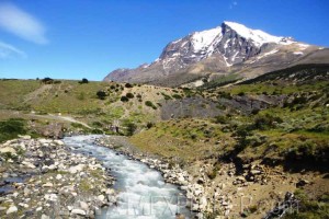
Located some 2.5 hours from Puerto Natales, the Laguna Amarga entrance gate can be reached taking a regular bus from the city’s terminal – only two daily frequencies. In this place you’ll officially enter the park, paying the required taxes and filling the entry form. From there it is necessary to walk another 7km (4.3mi) along an easy trail to the Las Torres Hotel (transfers are also provided for this segment). That’s where the trekking circuit itself starts.

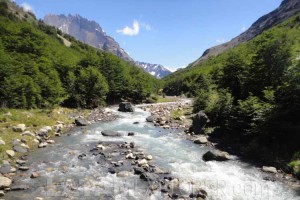
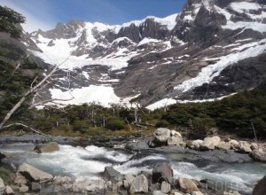
The first stretch is a 9km (5.6mi) leg until the viewpoint located in the base of the towers, subdivided in three segments. The hike begins with a 5km (3.1mi) walk upwards to the El Chileno mountain shelter, taking you from an altitude of 100m (330ft) to 450m (1,475ft).You can leave any unnecessary weight here (backpack and anything you won’t need for the next few hours) and then continue another 3km (1.8mi) forward until reaching the Torres camping site, on a moderate walk along the Ascencio river. Finally, the last kilometer is characterized by a hike to an altitude of 900m (2,950ft) leading to the Torres’ viewpoint. This is the toughest stretch of the first day, but the reward once you get there is extremely worth it: you’ll be in front of the Torres Lake and, behind it, the 3 Towers (Torres) del Paine. After a break to rest and take in the beauty of the place it is time to return to the shelter.

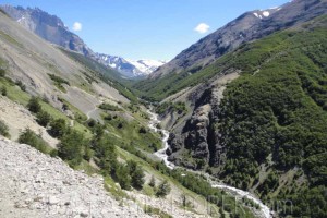
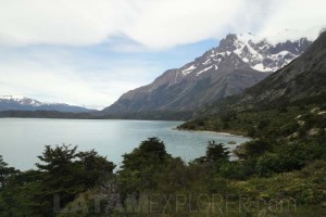
On my specific case, I had programmed the second day to stay around the Torre Central mountain shelter, without making any progress in the circuit. That became a hugely lucky choice, since the heavy rains falling on that day would have made the hike more difficult. I ended up spending most of the day indoors, exchanging experiences with other fellow travelers and continued towards the Los Cuernos shelter on the following day, for what would be the easiest walk of the whole circuit. The 12km (7.5mi) trail between the Torre Central and the Los Cuernos shelter is a walk without pronounced climbs, going around the Almirante Nieto Massif and lake Nordernskjöld, while also allowing beautiful sights over Sarmiento Lake. This segment can be completed in some 4 to 5 hours.

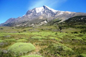
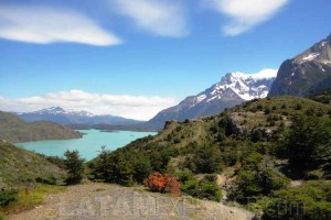
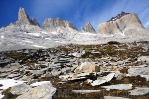
When I woke up early for my fourth day in the park, I had no idea what was waiting for me. The initial stretch of this segment is marked by a moderately easy 5km (3.1mi) hike to the Italian camping site, followed by another 5km (3.1mi) hike to the British viewpoint, passing through the British camp. This stretch, between the Italian and the British camping sites is known as the French Valley. The French viewpoint, at an altitude of 680m (2,230ft), slightly before reaching the British camp, presents an opportunity to observe in one single 360 degrees panorama the lakes Nordenskjöld, Pehoé and Toro in front, the Paine Grande mountain (3,050m – 10,000ft) to one side, the peaks Hoja (Blade, 2,200m – 7,215ft), Sword (2,250m – 7,380ft) and Fortaleza (Fortress, 2,681m – 8,795ft) to the other side and the Aleta de Tiburón (Shark’s Fin, 1,717m – 5,635ft) behind.

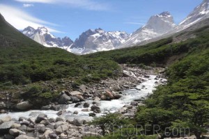
Continuing ahead, and passing the British camping site, I never realized I had passed through the viewpoint that should be the tipping point of the W Circuit. Because of that I kept hiking until I realized I was lost. Fortunately enough I found a Spanish couple that was trying to reach the base of the Towers through the western route and followed them until the Agostini Valley, about 1,400m (4,595ft) above the sea level. This caused me to run very late on that day’s schedule, but thanks to the long days of December (courtesy of Patagonia’s latitudes) I was still able to reach my planned destination, the Paine Grande mountain shelter, while the last moments of dusk still allowed me to see something, around 14 hours into my trekking day. My involuntary detour, visiting the Agostini Valley, allowed me to know a part of the park hardly seen by conventional tourists and that features extraordinarily beautiful sights (particularly as I was lucky to be there on a day with clear skies). This is not, however, a segment included in the official circuits of the park and it is not marked, besides presenting a considerably more difficult challenge than the rest of the W. I have to admit that, hadn’t I met this Spanish couple on my way (and their GPS), this story could have not been as pretty.

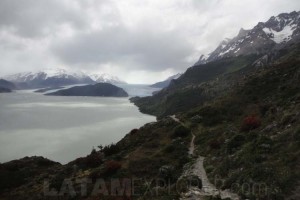
After the hard time I had in my previous day, the fifth and last of my W Circuit was quite calm. A moderately easy 10km (6.2mi) walk (some 3 to 4 hours) each way connects the Paine Grande shelter to the Grey Glacier viewpoint. I remember fighting against very strong winds that, at some points, momentarily forbade my progress. Nevertheless, the beautiful and wild scenery rewarded the effort and crowned my last few hours in the park with lasting memories. It would have been possible to take a boat and get a different perspective of the glacier, but I was already satisfied: for me, on that moment, nothing could be better than contemplate the greatness of the Grey from my standpoint, sat for about an hour on my favorite rock.

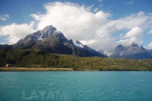
Back to the Paine Grande shelter it was time to bid farewell to the best trekking of my life. Yes, it would have been possible to walk another 5 hours to take the bus back to Puerto Natales, but I didn’t find that necessary. I took a ferry to cross Lake Pehoé and then board the bus back to town. In the end I walked about 90km, or 56mi, including my extensions to the original circuit exploring the Agostini Valley and getting closer to the Grey Glacier. Those were 5 days of intense contact with Mother Nature in sceneries as seldom seen by most people.

My choice for this trip, in order to allow for lighter packing and fewer worries, had me sleeping at the mountain shelters distributed along the circuit and operated by either one of the two companies licensed by the Chilean government to do so: Fantástico Sur and Vértice Patagonia. These shelters work pretty much as hostels and have a limited capacity so that, especially during high season, booking is required at least some two months ahead, usually earlier. A common alternative is to camp along the way on authorized camping sites. In this case, remember to strictly follow the safety protocols indicated by the forest rangers in order to avoid accidents, particularly fires.
Image Gallery